A project led by Dublin City Council has uncovered the history of the historic abbey that marked the founding of The Liberties.
11.04.17
The area we know today as The Liberties first developed as a self governing district or ‘liberty’ based around the medieval Abbey of St Thomas the Martyr. The Abbey was founded in 1177 on the orders of King Henry II of England. The King was the first Henry to engage in a struggle between Church and State in England that in 1170 had led to the murder of the Archbishop of Canterbury, Thomas Beckett (later made a saint) by some of Henry’s henchmen. As part of his atonement for the murder, Henry was required to endow a series of religious houses in England, and curiously here in Dublin in what was then his new Irish lands around the Pale.
The medieval Liberty of St Thomas & Donore thrived, given the abbey’s control of the western approach to the walled City of Dublin and its extensive lands in Meath, Dublin and Wicklow. Its wealth grew to the degree that it became a rich picking for a later Henry (VIII), who confiscated the abbey and its estates during the Dissolution of the Monasteries in the 1530s. The Liberty passed into the control of a courtier named William Brabazon and in time developed into the Earl of Meath’s Liberty. The Liberties lasted well into the 19th century until they were eventually abolished and subsumed into the city. The name, however, stuck.
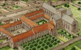
So where can we find St Thomas Abbey? Well the Abbey is long gone and little but archaeology of the abbey complex remains. Various bits of research has been undertaken over the years, but never a definitive study. However an exciting new project led by the Dublin City Archaeologist and the City Council’s South Central Area office has been piecing together the collective knowledge of St Thomas’s as well as more recent finds and discoveries.
The project is now nearing completion and a beautiful new publication of St Thomas Abbey and its history is planned, together with a major conference on the medieval Liberty to be held later in the year and a series of smaller events, walks and talks. The study has brought together various histories and research work, and includes knowledge gained from recent discoveries in the area such as 130 Thomas Street and the finds at the former Frawleys site, to paint the most detailed picture yet of the Abbey and its surrounds.
Its sure to be a fascinating publication and the book will be illustrated with specially-commissioned images of the Abbey and its environs in medieval times. Look out for details of the conference and events programme later in spring.
, to the rear of the former Frawleys or perhaps even 130 Thomas Street with its 1630s staircase!")
