Dublin ancient city walls stand testament to over 1,000 years of the history of the city
28.11.20
A section of wall at Cornmarket is one of the last visible reminders of the walls of Dublin, built by Viking kings and later the Anglo-Normans to encompass the then-town of Dublin.
Stone city walls appeared between 1100 and 1125 to replace the earthen defences that had until then protected the settlement of Dyflinn – a largely Viking town or longphort that had developed along the south bank of the River Liffey. The stone wall represented a coming of age for Dublin, in keeping with developments elsewhere in Europe, and signified the growth and preeminence of the port as the largest urban settlement in Ireland.
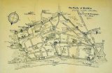
Although only limited sections of the wall survive today, almost the entire circuit can be traced by modern streets. Cook Street and Essex Street West form its northern limit, while Ship Street Little and Lamb Alley mark the southern run of the wall. When completed, the circuit would have been very imposing; a massive limestone structure towering to between 5m and 7m and up to 3m wide in places.
The most extensive section of wall that survives can be found on Cook Street, running for 83m and at least 10m high. From the vantage point of its recreated battlements, in what is now St Audoen’s Park, one can get a real sense of how formidable the city walls of Dublin were.
In 1170, new arrivals came to Dublin: the Anglo Normans. The Anglo Normans took control of Dublin and turned the town into a city, strengthening its fortifications and building gates, such as Newgate, at the western approach to the city at what is now Cornmarket. The Normans also built a moat at Dublin Castle, and from around 1240, began to extend the city wall to the north towards new quays on the River Liffey. This northern extension was added to the old wall, while new gates were inserted into the original circuit along Cook Street, including St Audoen’s Arch, which still remains.
The effectiveness of the walls varied during the 13th & 14th centuries as Dublin was subjected to repeated attacks from the rebellious clans who dominated the city’s hinterland out to the Wicklow Mountains. By the 16th century, the use of heavy ordnance rendered the walls incrreasingly inffective and by 1603 the south wall was in a state of ruin, while the quay wall was also described as ‘ruinous’ in 1607.
")
By the start of the 18th century, the expanding suburbs had largely engulfed the medieval core, and with the development of the Georgian city by the Wide Streets Commission most of the walls were removed, viewed as an impediment to expansion and improvement. The surviving sections remained either because they were hidden from view, or incoporated into buildings, or were simply fortunate enough not to be in the way of entrepreneurial developers.
In recent decades, the walls have re-emerged in people’s consciousness of the city. Sections of the wall have been conserved and protected. They stand as a poignant reminder of 1,000 years of the city’s extraordinary history.
(Extract from Dublin Through The Ages: The City Walls by Dublin City Council).
You can discover more about Dublin City Wall with this smartphone app developed by Dublin City Heritage Office and Dublinia.
Find out more about Medieval Dublin.

