
As Old As Dublin Itself
The city of Dublin grew from two small settlements at the confluence of the River Liffey and one of its tributaries, the Poddle. The original settlements were known as Áth Cliath (The Ford of Hurdles) and Dubh Linn (The Black Pool), which was later anglicized to Dublin.
In medieval times, the city was walled for its protection and administered by a corporation and guilds who controlled trade and commerce within the city, administered justice, and levied tariffs and taxes to run and protect the city. Beyond the walls, a number of areas outside of the Corporation’s control were established called liberties, largely run by religious instititions.


The early Liberties
In the 12th century, King Henry II of England ordered an Abbey of St Thomas the Martyr to be established at a site close to the modern church of St Catherine on Thomas Street. The Augustinian monks of the Abbey were given extensive lands to the west of the city, as well as in counties Dublin, Meath and Wicklow, and certain privileges and powers to control trade within their ‘liberty’ and as a result the Liberty of St Thomas Court & Donore became extremely wealthy. The abbey in turn gave its name to St Thomas Street, the main street of the area, which itself ran along the alignment of the ancient western route into the city of Dublin. It quickly became a bustling marketplace and trading street, lined with mills, hostelries and various providers all serving the growing city.
With the dissolution of monasteries by King Henry VIII in the 1530s, the abbey’s lands passed into the ownership of Sir William Brabazon, an ambitious courtier of the king. The Brabazon family, who later became Earls of Meath, dominated the area as landowners for the next 300 years and different generations of the family were responsible for many of the urban developments we recognise today. The great market space at Newmarket was laid out in the 1620s by the second Earl of Meath and his townhouse was located close by. A later earl supported some of the pioneering Victorian-era housing developments for the working class. Today, streetnames such as Meath Street, Brabazon Street and Ardee Street evoke the family connection.


Dublin’s Industrial Suburb
The mercantile character of the area attracted generations of tradesmen and crafts. The area grew into an industrial suburb of Dublin, with an extensive tradition of brewing, distilling, tanning, weaving and trade in agricultural produce.
In the 16th and 17th centuries the area had a notable Huguenot population and became a centre of excellence in silverwork, wool and silk weaving, as well as ‘dirty industries’ such as tanning (leather making). European tradesmen brought their own distinctive architectural styles to the city, such as gable-fronted houses or ‘Dutch Billys’ as they were known, and these houses became a feature of areas such as Pimlico, Spitalfields and The Tenters. The area’s placenames reflected its diverse and international population: so Marrowbone Lane (or Marie le Bon Lane), Chambre Street (Chamber Street) and Fumbally Lane (Fombily Lane) reflect the area’s French Huguenot community.
The area’s growing craft industries drew resistance from English merchants and a series of laws and trade restrictions imposed on Irish produce after the Act of Union in 1801 gradually destroyed a number of key industries. The area began to decline economically.


Fame and Fortune
During the late 18th and 19th century, The Liberties was dominated by great brewing and distilling families, most notably the Guinness family, who from 1759 built and developed the world’s largest brewery at St James’s Gate. Renowned distillers Powers, Jameson, Millar and Roe were all located here, creating a Victorian cityscape of chimneystacks, mills, malthouses and bustling streets. The area even had its own harbour linking it to the Grand Canal, and a mini-railway through the St James’s Gate brewery to the River Liffey quays.
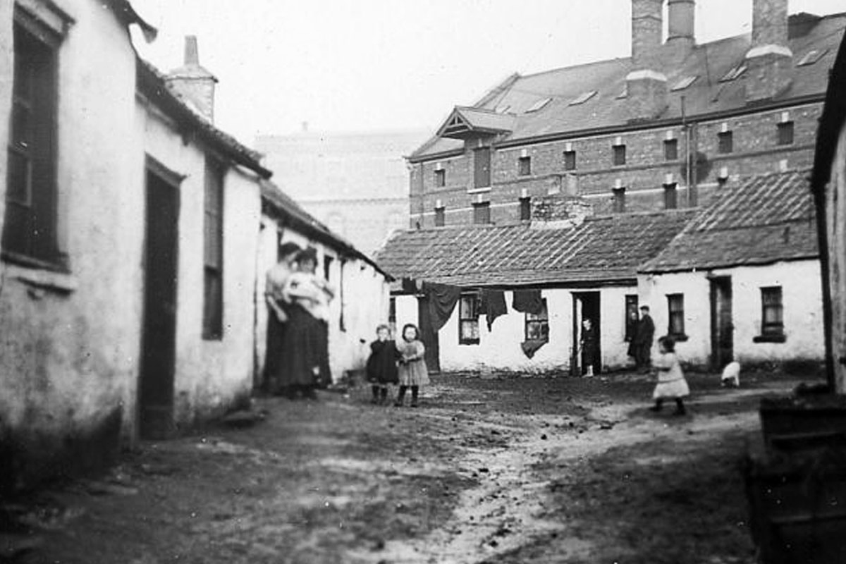
However this industrial wealth and prowess went hand in hand with dire poverty and often horrendous living conditions. The 19th century Liberties had notorious slums which in turn spurred a number of enlightening housing developments by the Earl of Meath and the Guinness and Power families in the latter years of the century. The now-charming enclaves about Gray Street and John Dillon Street were originally examples of modern new homes built for the working class by the Dublin Artisan Dwelling Company, while the Iveagh Trust Buildings on Patrick Street remain beautiful examples of the first ‘flats’ built for Dubliners.
The ancient ‘liberties’ were finally abolished and subsumed into the city in the 1840s, however the name ‘The Liberties’ remained and became primarily to mean the old Earl of Meath’s Liberty.

While the fortunes of the area declined in the 20th century, Thomas Street and Meath Street remained the quintessential heart of Auld Dublin, renowned in song and story. The area has produced its fair share of storytellers, master musicians, street characters and thespians.
Today, it retains its distinctive character and curious detachment from the life of the wider city. It’s a place to discover and enjoy: a place of evocative placenames, engaging architecture, vibrant street life and strong community spirit.

Liberties were a feature of many medieval walled cities under Anglo-Norman control, and there were also liberties in Cork and London. In Dublin, a number of liberties were granted by the city’s first Anglo-Norman conqueror, King Henry II, each with different rulers to maintain a delicate power balance. So the Liberty of St Thomas Court & Donore was attached to the Abbey of St Thomas the Martyr (and later the Earls of Meath), while the Liberty of St Sepulchure was attached to St Sepulchure’s Palace, once the home of Dublin’s Archbishops (and now a police station!).

For centuries, James Street and Thomas Street formed part of a well-trodden pilgrim route that led all the way to the north of Spain - the famous Camino de Santiago (St James) de Compostella. The Church of St James on James’s Street retains its connections to Compostella to this day, and even offers modern pilgrims a stamp for their Camino passport as they take the pilgrim way. Across the street, the Pearse Lyons Distillery, itself in the former Church of Ireland of St James, boasts a spectacular stained-glass window telling the story of the Camino.

John’s Lane Church (or the Church of St Augustine & St John the Baptist as it is properly called), is one of the most identifiable landmarks of The Liberties, noted for its soaring steeple. In fact, at just under 68m high, the steeple is the tallest in Dublin and one of the city’s most ornate landmarks. The sculptures that adorn the steeple were the work of William Pearse, father to Padraig Pearse, one of the seven leaders of the 1916 Easter Rising. Its politically-active builders and masons gave the church its alternative nickname, The Fenian Church. The building itself was designed by E W Pugin, among the greatest of Victorian-era church builders, and includes richly decorated interiors.

Shake the average can of Guinness, brewed right here in The Liberties at St James’s Gate Brewery and you’ll hear a curious rattle. It belongs to the famous Guinness Widget, an innovation designed at St James’s Gate as a means of retaining gas in the can and helping to create the perfect pint with its creamy Guinness head when the can is poured. It’s actually a small plastic ball with a tiny hole that helps to quickly release the beer when the can is opened, and thus creates bubbles needed for that all-important creamy ‘head’.

Given that you’re in one of Dublin’s most historic neighbourhoods, it seems appropriate that the oldest house in Dublin has been discovered in The Liberties. In an exciting discovery at 130 Thomas Street, conservation works in 2017 uncovered an ancient staircase from 1639, and wooden beams which were carbon-tested dated right back to 15th century. Interestingly the building does not appear special from the outside – its facade is typical of the 19th century. The building, which forms an important footnote in the history of The Liberties, can be seen opposite St Catherine’s Church.

As you wander The Liberties, keep your eyes out for some of the more curious placenames. Walk along Oliver Bond Street and you’d almost miss Mullinahack and Wormwood Gate. Strolling to The Guinness Storehouse you stop on Sugar House Lane and Bellevue. While down off Meath Street lies Engine Alley and Cross Stick Alley. Some of the area’s placenames refer to the former trades that took place here over the centuries – such as Cook Street, Fishamble Street and Winetavern Street. Others refer to the Brabazon family, Earls of Meath who once controlled much of The Liberties.

For over 500 years, the Brabazon Family has had strong connections to The Liberties. In 1534, Sir William Brabazon was dispatched to Dublin by Thomas Cromwell, secretary to Henry VIII, as part of the new Irish Establishment to represent the Tudor king in military campaigns against Gaelic clans. During the 1550s he was given several titles including Vice-Treasurer, Receiver General, and later, Lord Justice. He died in the summer of 1552 on a military campaign against the O’Neills at Carrickfergus. His heart was removed and carried to England for a heart-burial, interred in the family tomb at Eastwell in the north-eastern part of Leicestershire. His body was buried under the chancel of St. Catherine's Church on Thomas Street.